Rauscher Logo 180
Left border bird box
Maps

Click on the maps on this page to view larger images.

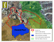
Directions to Rauscher Farm
29 Clamshell Road
Clinton, MA

Coming From Route 62 East & Route 70 South: Follow Rt. 62 / Rt. 70. Just past the Wachusett Dam  turn right on Cameron Street (by the Cumberland Farms store). In about 1/4 mile bear right onto Berlin St. Turn  right opposite the Philbin Memorial Playground onto Wilson Street. Follow Wilson Street for 1/3 mile. Bear left onto Clamshell Road until you come to Rauscher Farm (½ mile).

Coming From Route 62 West & Route 70 North: Follow Rt. 62 / Rt. 70 past the Nypro factory and over the Nashua River bridge. Turn left onto Cameron Street (by the Cumberland Farms store). In about 1/4 mile bear right onto Berlin St. Turn  right opposite the Philbin Memorial Playground onto Wilson Street. Follow Wilson Street for 1/3 mile. Bear left onto Clamshell Road until you come to Rauscher Farm (½ mile)

RF_Location
Farm Management Units Map
2021 rf_barnmap 36.5x48_0621_72l

Land Management Areas on Rauscher Farm

Walking Trails on Rauscher Farm

Maps Below are Courtesy of
Sudbury Valley Trustees
 Click on thumbnails for larger images.   

Rauscher Farm has high conservation value. It is adjacent to Massachusetts Natural Heritage and Endangered Species Program conservation areas.

Rauscher Farm borders other important protected areas. It is part of the natural range of many species of animals inhabiting the area from the Wachusett Reservoir throughout the Sudbury / Concord River valley.


Rauscher Farm connects with a network of contiguous protected areas that are under the stewardship of the Sudbury Valley Trustees (SVT). Preserving Rausher Farm as open space protects the habitat of many plant and animal species.